


Description de PhoneMaps
Mobile phone app PhoneMaps offers FOR FREE zoomable hiking and cycling maps with full network of marked hiking and cycling routes of almost whole Europe. In app you can plan your holiday, during the activity orientate in terrain and record your tracks and experiences and then share them with your friends. Hiking or cycling content with marked hiking/cycling routes you will not find in general map applications in your phone, you will not need to go to bookshop and buy paper map.
- Language: English, German, Czech, Slovak, Polish, Italian, Chinese
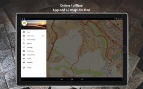
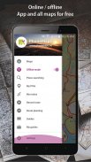
- Online and offline maps
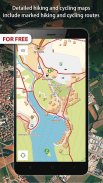
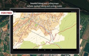
- Detailed hiking and cycling maps include marked hiking and cycling routes
- Maps created by cartographic companies freytag&berndt and SHOCart
- Hiking and travel guides from Bergverlag Rother, freytag&berndt
- Vector maps: smaller, can be easily zoomable and rotated
- Download map of area where you will go, map tiles are displayed as one map
- All points in maps with interactive information (address, website, email, timetable, ....)
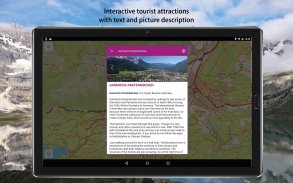
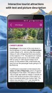
- Interactive tourist attractions in maps (photos and texts)
- Current GPS position
- Locality searching
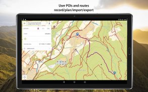
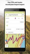
- Record/import/export/management of user routes (gpx)
- Record user Points of interest
- Spatially localized taking photos in app
- Online routing and searching of optimal routes in a map (for hikers, cyclers, cars)
- Statistics of routes + elevation models of routes
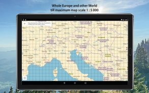
- Hiking / cycling map till 1:5 000 - Andorra, Austria, Belgium, Bulgaria, Croatia, Czech Republic, Denmark, Estonia, Finland, France, Germany, Greece, Ireland, Israel, Italy, Hungary, Latvia, Lichtenstein, Lithuania, Luxembourg, Monaco, Montenegro, Netherlands, Norway, Poland, Romania, San Marino, Spain, Slovakia, Slovenia, Sweden, Switzerland, United Kingdom, USA, Nepal, Japan, Taiwan, New Zealand, Israel, Kilimanjaro
- Topographic map 1:5 000 - rest of the world
AND THE BEST THING IS THAT APP AND ALL MAPS AND FUNCTIONS IN APP ARE FOR FREE!
Application pour téléphone mobile PhoneMaps propose GRATUITEMENT des cartes de randonnée à pied et à vélo zoomables avec un réseau complet de sentiers de randonnée à pied et à vélo balisés de presque toute l'Europe. Dans l'application, vous pouvez planifier vos vacances, pendant l'activité, orientez-vous sur un terrain et enregistrez vos traces et expériences, puis partagez-les avec vos amis. Le contenu de randonnées pédestres ou cyclistes comportant des itinéraires balisés, que vous ne trouverez pas dans les applications cartographiques générales de votre téléphone, vous n’aurez pas besoin d’aller dans une librairie et d’acheter une carte papier.
- Langue: anglais, allemand, tchèque, slovaque, polonais, italien, chinois
- Cartes en ligne et hors ligne
- Les cartes détaillées des randonnées pédestres et cyclistes incluent des itinéraires balisés
- Cartes créées par les sociétés de cartographie freytag & berndt et SHOCart
- Guides de randonnée et de voyage de Bergverlag Rother, freytag & berndt
- Cartes vectorielles: plus petites, peuvent être facilement zoomées et pivotées
- Téléchargez la carte de la région où vous irez, les tuiles de carte sont affichées comme une carte
- Tous les points sur les cartes avec des informations interactives (adresse, site web, email, calendrier, ....)
- Attractions touristiques interactives sur des cartes (photos et textes)
- Position GPS actuelle
- Recherche de localité
- Enregistrement / importation / exportation / gestion des itinéraires utilisateur (gpx)
- Enregistrer les points d'intérêt de l'utilisateur
- Prendre des photos spatialement localisées dans l'application
- Itinéraire en ligne et recherche des itinéraires optimaux sur une carte (pour les randonneurs, les cyclistes, les voitures)
- Statistiques de routes + modèles d'altitude de routes
- Carte de randonnée / cyclisme jusqu’à 1: 5 000 - Andorre, Autriche, Belgique, Bulgarie, Croatie, République tchèque, Danemark, Estonie, Finlande, France, Allemagne, Grèce, Irlande, Israël, Italie, Hongrie, Lettonie, Lichtenstein, Lituanie, Luxembourg, Monaco, Monténégro, Pays-Bas, Norvège, Pologne, Roumanie, Saint-Marin, Espagne, Slovaquie, Slovénie, Suède, Suisse, Royaume-Uni, États-Unis, Népal, Japon, Taïwan, Nouvelle-Zélande, Israël, Kilimandjaro
- Carte topographique 1: 5 000 - reste du monde
Et la meilleure chose est que l'application et toutes les cartes et les fonctions de l'application sont gratuites!
PhoneMaps - Version 99.0
(14-04-2020)PhoneMaps - Information APK
Version APK: 99.0Package: eu.phonemapsApplications de même catégorie
Vous pourriez également aimer...


